Repository: charleyglynn/OSM-Shapefile-QGIS-stylesheets
Branch: master
Commit: 09b88e606cf9
Files: 20
Total size: 357.7 KB
Directory structure:
gitextract_cgezbnn1/
├── .gitignore
├── QML files/
│ ├── buildings.qml
│ ├── greyscale/
│ │ ├── README.md
│ │ ├── buildings.qml
│ │ ├── land_polygons.qml
│ │ ├── landuse.qml
│ │ ├── natural.qml
│ │ ├── places.qml
│ │ ├── railways.qml
│ │ ├── roads.qml
│ │ └── waterways.qml
│ ├── land_polygons.qml
│ ├── landuse.qml
│ ├── natural.qml
│ ├── places.qml
│ ├── railways.qml
│ ├── roads.qml
│ ├── water.qml
│ └── waterways.qml
└── README.md
================================================
FILE CONTENTS
================================================
================================================
FILE: .gitignore
================================================
*~
================================================
FILE: QML files/buildings.qml
================================================
000name../..../..00generatedlayout2
================================================
FILE: QML files/greyscale/README.md
================================================
## Greyscale styles for OSM shapefiles in QGIS
Simple translation of @charleyglynn's colour styles
================================================
FILE: QML files/greyscale/buildings.qml
================================================
000name.0.generatedlayout
================================================
FILE: QML files/greyscale/land_polygons.qml
================================================
000FID0generatedlayout
================================================
FILE: QML files/greyscale/landuse.qml
================================================
000name.0.generatedlayout
================================================
FILE: QML files/greyscale/natural.qml
================================================
000name.0.generatedlayout
================================================
FILE: QML files/greyscale/places.qml
================================================
000namename.0.generatedlayout
================================================
FILE: QML files/greyscale/railways.qml
================================================
000name.0.generatedlayout
================================================
FILE: QML files/greyscale/roads.qml
================================================
000name.0.generatedlayout
================================================
FILE: QML files/greyscale/waterways.qml
================================================
000name.0.generatedlayout
================================================
FILE: QML files/land_polygons.qml
================================================
000FID00generatedlayout2
================================================
FILE: QML files/landuse.qml
================================================
000name../..../..00generatedlayout2
================================================
FILE: QML files/natural.qml
================================================
000name../..../..0.0generatedlayout2
================================================
FILE: QML files/places.qml
================================================
000namename.0.generatedlayout
================================================
FILE: QML files/railways.qml
================================================
000name..00generatedlayout1
================================================
FILE: QML files/roads.qml
================================================
000name../..../..00generatedlayout1
================================================
FILE: QML files/water.qml
================================================
000name..0.0generatedlayout2
================================================
FILE: QML files/waterways.qml
================================================
000name..00generatedlayout1
================================================
FILE: README.md
================================================
OSM Shapefile QGIS stylesheets
==============================
*This repo contains QGIS stylesheets (QML) for use with OpenStreetMap (OSM) data in ESRI Shapefile format. It now also contains greyscale stylesheets courtesy of @mixedbredie*
==============================
## Background
I quite often use OSM data for personal mapping projects and I always use the ESRI Shapefiles from [Geofabrik](http://download.geofabrik.de/).
There aren't many stylesheets available for use with this data so I decided to make my own. I found [this set](https://github.com/3liz/osm-in-qgis) from 3liz and used them as my starting point.
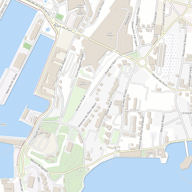
## Info
These stylesheets have been designed to work at a large scale (1:4,000). They are legible between 1:2,000 and 1:5,000. I may adapt them to work at more scales in the future if need/time permits.
They have been made to work with ESRI Shapefiles from [Geofabrik](http://download.geofabrik.de/) and land polygons from [OpenStreetMapData](http://openstreetmapdata.com/data/land-polygons).
For the sea tint you will need to set your background colour to **R** 184 **G** 217 **B** 247.
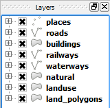
I recommend this layer order:
## Credit & Licence
Thanks to the guys at [Geofabrik](http://download.geofabrik.de/) and [OpenStreetMapData](http://openstreetmapdata.com/data/land-polygons) for providing the ESRI Shapefiles.
Thanks to the guys at [3liz](http://www.3liz.com/) for providing the set of stylesheets that I used initially.
They are licensed under [CC-BY-SA](http://creativecommons.org/licenses/by-sa/3.0/) so you are free to use these stylesheets under the same terms.